
BMW Maps Gets a Tesla-Style Redesign for Electric Vehicles
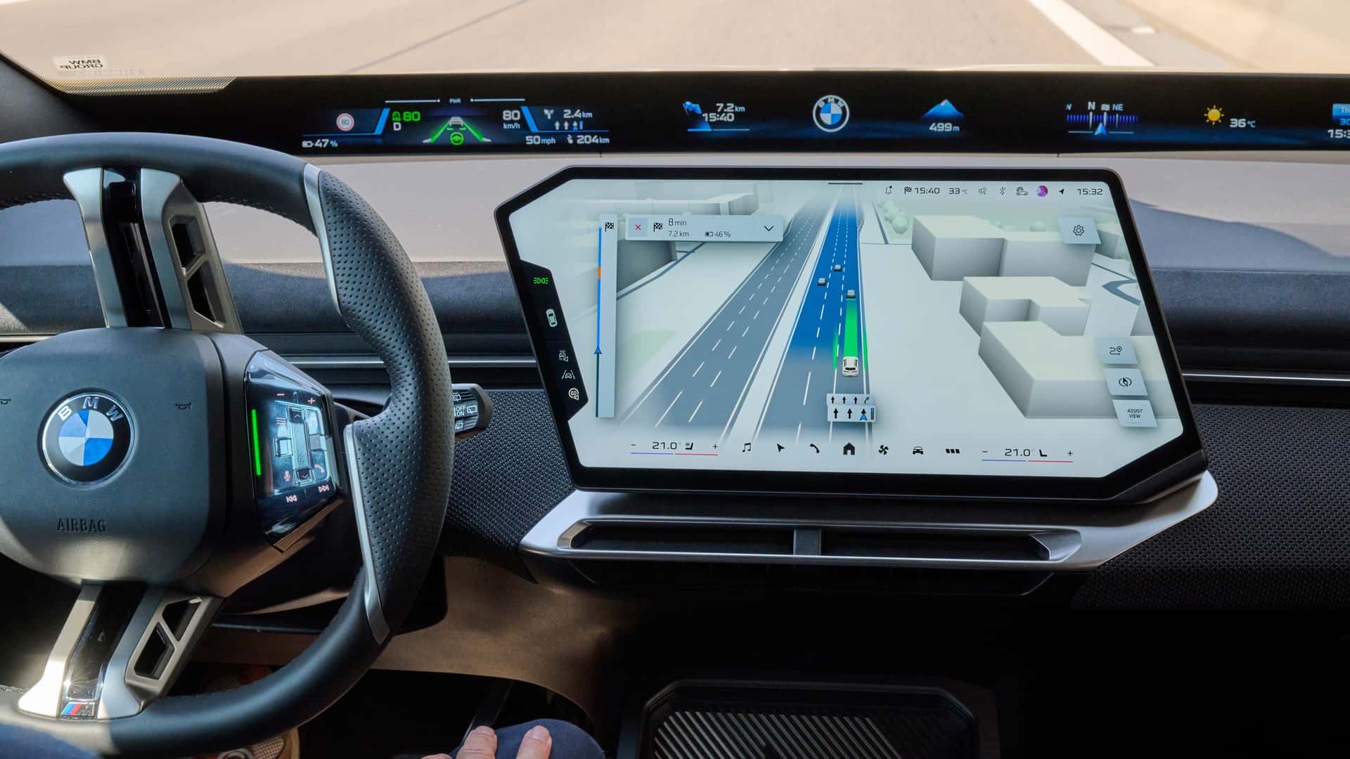
BMW is debuting a dramatic overhaul of its digital user interface, reshaping how drivers interact with navigation and driver assistance systems. Beginning next month, the Bavarian automaker is rolling out a redesigned BMW Maps experience that merges route guidance and active safety notifications into a single dynamic display. The system debuts alongside the company’s new BMW Operating System X on the incoming iX3 electric crossover.
The redesigned digital cockpit takes a clear cue from modern software-centric vehicle architecture, replacing disconnected menus with an integrated three-dimensional visualization. Drivers will now see a real-time rendering of their vehicle situated precisely within its lane. The interface displays upcoming navigational maneuvers alongside active automated driving status, offering a unified operational picture during complex trips.
This structural shift directly mirrors the intuitive visualization displays popularized by industry rivals, where environmental perception and route planning exist on the same screen. By combining vehicle telemetry with mapping graphics, BMW aims to eliminate cognitive load. Drivers no longer need to check separate displays to confirm what the vehicle’s sensor suite detects relative to their planned destination.
A Unified Visual Experience for Next-Generation Cockpits
The updated BMW Maps application displays lane positioning at true-to-life elevation levels while rendering surrounding traffic directly on the central infotainment display. Whether navigating multi-lane highway splits or dense gridlock, the software dynamically shows nearby passenger cars, commercial vehicles, and road boundaries in real time. This contextual awareness gives drivers immediate confirmation of the system’s perception capabilities.
According to technical documentation released by the automaker, the updated interface significantly enhances clarity at complicated urban intersections and highway merges. As semi-automated systems assume greater responsibility over steering and speed, clear visual feedback becomes critical. The new layout overlays assist inputs seamlessly over the map, showing planned trajectory changes before the vehicle executes them automatically.
For initial buyers of the new BMW iX3, the visual interface will complement the company’s Highway Assistant system. This technology allows for hands-free driving on designated divided highways at speeds reaching 80 miles per hour, or 130 kilometers per hour. The dynamic display shows lane changes and hands-free availability zones with high-definition graphic prompts directly integrated into the flow of navigation.
Deep Integration of Mapbox Data and Real-Time Telemetry
While BMW engineered the software architecture and visual rendering engine in-house, the underlying geospatial data relies on technology provided by Mapbox. The mapping platform supplies precise lane geometry, physical landmarks, speed restrictions, and local road features. This rich location layer allows the vehicle to render recognizable real-world environments on screen rather than relying on abstract vector representations.
The partnership with Mapbox enables high-definition mapping data to synchronize instantly with onboard camera, radar, and sensor inputs. By fusing localized mapping information with real-time perception data, Operating System X can project accurate surroundings even in complex multi-tier highway interchanges. This hybrid data approach ensures low latency and robust visual fidelity across diverse driving conditions.
Industry filings indicate that the updated mapping and driver assistance features will initially be restricted to specific regional configurations. Availability depends on local regulatory approvals, HD map coverage, and vehicle equipment packages. Early promotional material captured on North American roadways confirms that key highway corridors and metropolitan centers in the United States will be among the first supported areas.
Preparing for Automated Urban Driving in Global Markets
The visual redesign represents more than a simple aesthetic refresh; it serves as the foundational user interface for higher levels of vehicle autonomy. BMW is actively preparing to deploy navigation-guided, semi-automated driving in urban environments. This advanced functionality is scheduled to debut in Germany by 2027 before expanding to additional international jurisdictions as regulatory frameworks permit.
Navigating city streets autonomously requires an unprecedented degree of driver trust, which transparent visual feedback helps establish. By showing pedestrians, traffic light signals, and complex turn lanes within the main navigation view, BMW seeks to build driver confidence. The system clearly indicates when automated intervention is active and what decisions the vehicle’s central computing architecture is anticipating.
Expanding the Operating System X Ecosystem Across the Fleet
The iX3 electric SUV is merely the vanguard for BMW’s broader Neue Klasse EV platform rollout. Following its initial debut on the iX3 crossover, Operating System X and its integrated 3D mapping platform will expand to several upcoming models. Confirmed recipients include the upcoming i3 sedan, the larger iX5 crossover, and a refreshed flagship i7 luxury sedan.
As software becomes the primary differentiator in the premium EV market, BMW’s overhaul of its navigation ecosystem marks a crucial step forward. By combining advanced driver assistance telemetry with rich, lane-level mapping on a single screen, the German automaker is asserting its place at the forefront of digital vehicle design and semi-autonomous driving.
